Category Archives: osm.org

Change to ODbL imminent

Hello OpenStreetMap-pers,

The change to ODbL is imminent. No, Really. We mean it.

At long last we are at the end of the license change process. After four years of consultation, debate, revision, improvement, revision, debate, improvement, implementation, coding and mapping, mapping, mapping, it comes down to this final step. And this final step is an easy one, because we have all pitched in to do the hard work in advance. The last step is so easy, it will be a picnic.

On Wednesday, 12 September 2012[1], generation of the next Planet file will begin. At that point, the API will switch over to ODbL and OpenStreetMap will be an ODbL-licensed Open Data project. API transactions and diffs consumed after that point will consist of ODbL-licensed OpenStreetMap data.

About thirty hours later, that newly-generated planet file will be available from planet.openstreetmap.org for you to consume with your renderers, routers, QA systems, convertors and re-imaginers.

You won’t want to mix ODbL diffs with old license planets or diffs. Purge and reload your systems with the ODbL planet. Then consume the ODbL diffs. Planet will have a new directory structure. We’re taking this opportunity to rationalize the layout of planet directories a bit. You should find it easier to understand afterwards. This also means that you won’t accidentally mix data of different licenses.

Mappers

Mappers shouldn’t see a difference and won’t have to change their mapping. Continue to improve OpenStreetMap by mapping from your own survey observations and using OSM-approved external sources. Never copy from other maps.

Data consumers

If you consume OpenStreetMap data and publish it, we have some guidance for you on the wiki. You’ll want to consider your obligations under the new license and then proceed to purge your old data and switch to the new. Many consumers, such as custom renderers, will only need to update their attribution of OpenStreetMap to the new simplified attribution.

Data consumers may time their upgrades to the new planet and diffs at their convenience.

Best regards and happy mapping,
The Communication Working Group

[1] in case of rain, we won’t cancel this picnic, just reschedule it for the subsequent Wednesday, 19 September 2012.

Image credit

Photo of cat in picnic basket is © Jacob Davies, licensed CC-By-SA.

API Read – Write returns

The sysadmin team completed the data base migration to the new DB server on schedule during the the morning of 04 April 2012. The API is now back to normal, Read – Write operation. Now the final steps of the license upgrade will proceed as outlined in the March – April service schedule announcement

Other items of possible interest as the license upgrade process proceeds:

osm.org map tile generation will recommence within the next few hours.

Replication diffs during the license upgrade period have started after community requests. These cc-by-sa data replication diffs are found in the redaction-period directory on planet. planet.openstreetmap.org/redaction-period. These diffs will only serve the period up until the switch to the new license. Mappers have requested these diffs for the redaction period. General consumers of OSM data may choose to consume these diffs or not at their discretion.

ODbL diffs will be located in another directory to be announced in future.

During the redaction period it is recommended that editors save their work early and often to reduce the chances of, and the complexity of conflicts with the back ground redaction process.

Database downtime – 20 March 2012

On Tuesday 20th of March 2012 between 13:45 and 16:15 (GMT / UTC) the
primary database server will unavailable due to emergency maintenance.

The following services will be affected:

  • www.openstreetmap.org web site will not allow user login or edits (Potlatch). [1]
  • API and map database editing (using JOSM, Merkaartor etc.) will be unavailable.
  • planet.openstreetmap.org will be available but no new diffs will be generated during the outage.
  • Forum (no logins)
  • trac (bug-tracker, no logins)
  • help.openstreetmap.org (no logins)

Other services will not be affected – all of the following are
expected to function normally:

  • tile serving (“View The Map” & “Export”)
  • Wiki
  • Nominatim (search)
  • mailing lists
  • subversion and git (source code repositories)
  • donate.openstreetmap.org

Technical: Database Server Smaug: Replacing faulty motherboard.
Supplier Engineer Onsite. We have contingency hardware available.

1: Maps will still be viewable on the openstreetmap.org homepage and
on other people’s websites.

Sincerely
Grant Slater
On behalf of the OpenStreetMap sysadmin team

Top Ten Tasks

Contribute to the OpenStreetMap developer community by getting involved in the Top Ten Tasks!

OpenStreetMap is huge, with an extensive and varied community. Our data is used in applications for specialty and general audiences, for devices common and rare. The infrastructure that we rely upon, as members of the OpenStreetMap community is continually improved in ways more- or less-visible and with more or less celebration.
As an example, we’ve improved our friends recently. This is a small, visible improvement in the OSM web site. You might just think, “Wow, how did we go so long without this function?” If you are logged into the web site, now you can view the recent changesets by the contributors that you have added as your friends.

http://openstreetmap.org/browse/friends

This new feature sprang from a discussion on the talk@ list two weeks ago. Toby Murray made the suggestion. Mikel Maron liked the idea so much that he wrote some code[1] and Tom Hughes refined Mikel’s patch then merged it into the rails port so that we can all use it.

There are many other ways, large and small, for developers to contribute to OpenStreetMap. The Engineering Working Group, has updated the Top Ten Tasks list with some eagerly anticipated projects. There are projects that involve Rails, javascript, flash, flex, python, django and others. If you have always wanted to dig into a substantial project, with other top-notch developers, these are the projects for you.

Photo ©R.Weait, used by permission.

What’s new on OpenStreetMap.org?

Swan photo by Tony the Misfit is licensed CC-By

We spend a lot of time talking about the amazing map our users are producing, but perhaps not enough about the technology that enables it all. But it’s worth shouting about: from the reliable Ruby code that puts stuff into our super-efficient Postgres database setup, to the speedy hardcore cgimap code that sends it out to editors, to the wizardry of Mapnik that makes it all into beautiful maps… like the swan, there’s a lot of effort underneath the surface, but it all seems serene above water.

In fact, there’s a constant stream of changes aimed at making OpenStreetMap easier to use – big ones, yes, but also “little things that mean a lot”. So, for example, in the last month we’ve improved the “users near you” map (thanks to Martijn van Exel) and fixed potential security issues (thanks, as ever, to Tom Hughes). We’re also finishing up a move to Rails 3, which will help us make more user interface improvements, and keep the code clean. We’ll tell you more about these changes as they happen.

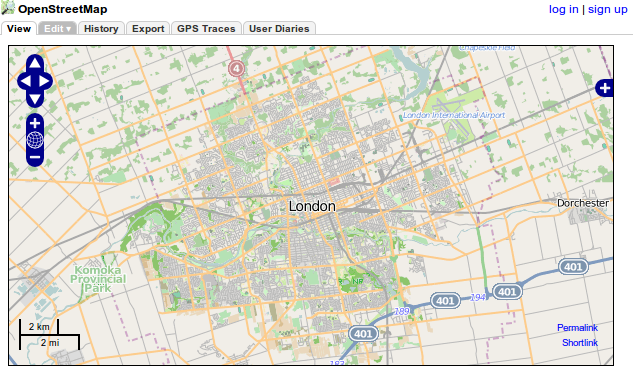
Have you noticed that osm.org adjusts to smaller screens with smaller tabs? It does now. Map CC-By-SA

Our Potlatch 2 editor has also had a whole bunch of improvements. It’s now much easier to draw shapes with holes (“multipolygons”), the GPS track handling is cleverer, and we have a clever feature where you can replace a node with a whole new one (select the old one and press O). We’ve incorporated a number of suggestions from usability research, and there’s still more to come.

If you’re a developer, we’d love to have your help with OpenStreetMap. There’s so much to do! You can find out about our codebase at http://wiki.openstreetmap.org/wiki/Rails, and join the rails-dev mailing list to bounce ideas off other developers. Or if you’d like to help with Potlatch 2, see http://wiki.openstreetmap.org/wiki/Potlatch and the potlatch-dev mailing list.

Downtime announcement: 23 June 2011

Thursday 23rd June 2011 7:30am (GMT/UTC+0) the API and map data editing on www.openstreetmap.org will be unavailable. The maintenance period is expected to last for 12 hours.

The following services will be unavailable during the maintenance period:
API, editing features of www.openstreetmap.org and planet.openstreetmap.org including replication diffs.

The wiki, mailing lists and help.openstreetmap.org will be unaffected.

Technical: Some of the core servers are being re-located to another data-centre.

Additional information will be posted on the wiki as the maintenance window approaches:
http://wiki.openstreetmap.org/wiki/Servers/June_2011_Maintenance

Tile server upgrade

The OpenStreetMap server team has upgraded the tile server to render changes faster. Demand for OpenStreetMap tiles has increased steadily as the project grows. Recent increases in demand for tiles has lead to long waiting times for mappers who want to see the results of their improvements to the map.

Thanks go to Grant Slater, Jon Burgess, the Mapnik.org team, and many others who keep improving OpenStreetMap every day in ways large and small.

Read the announcement and hardware details on talk@.

Speedometer photo by Nathan E Photography is licensed CC-By

New Changeset display

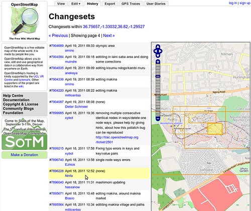
The OpenStreetMap web site was updated today. When you view the history tab, you’ll now see a map with bounding boxes shown for recent changesets in the area. Hovering over the changeset will highlight the bounding box, and vice-versa.

This improvement was coded by Mikel and refined by Mikel and TomH.

Read more about this from Mikel’s announcement on his blog.