OpenStreetMap Baghdad is happenning. This is incredible and exciting. And we need your help. Please read on.
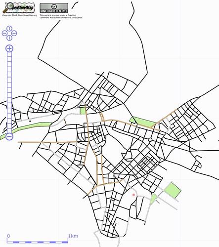
OpenStreetMap is an free and open collaborative map of the entire world. We gather GPS tracks and draw maps over them, in an editable wiki style database. And recently we added aerial imagery to our toolbox, thanks to Yahoo!, so dense urban areas and remote locations can be mapped just by tracing streets in the web browser.
This means that OpenStreetMap has the most comprehensive map of Baghdad among any of the web mapping services.
Yahoo has great coverage over Baghdad, and we’ve been tracing. But since we’re physically just about everywhere else in the world but Baghdad, we don’t know the names of the streets or the neighborhoods, and especially what’s changed and still changing during these years of conflict.
So we’re reaching out to find people who could help .. people in Iraq now or have been in Iraq. Data sources, like any old maps or geographic names databases that are permissible to use would be very useful. Or crucially at this point, people who might know people who might know these people and sources. Maybe that’s you.
Our core belief is that open and accessible geodata helps people. The BBC reported on Iraqis using Google Earth to safely travel and avoid violence.
We are well aware of the huge challenges here, culturally and technically. There’s been discussion on how to handle the multiple names of streets .. the old names under Saddam, new names under different factions, and the government. OpenStreetMap can handle all endonyms .. names should exist by use not prescription. And that’s just scratching the surface of the issues. But right now is the right time for proving the open collaborative model for geodata, in the places that need it the most, and OpenStreetMap is ready to take it on.
So any help is welcome .. forward an email, blog post, CNN .. anywhere closer to people that can make OpenStreetMap Baghdad take off. And any comments or discussions, positive or negative, are welcome too.