State Of The Map – Register now for early bird prices

Tomorrow is the last day of May, and your last chance to grab yourself a “State Of The Map” conference ticket at the reduced “Early-bird” prices.

State Of The Map is the international annual conference of the OpenStreetMap foundation. There’s a lot of excitement about stateofthemap.us taking place in San Francisico in just over a week’s time. This is shaping up very nicely, and registration is still open. It is organised by OpenStreetMap U.S., and is followed by SOTM Baltics in August. Various other local chapters are running their own local conferences. ….but the main event….

State Of The Map is taking place in Birmingham, England. 6-8th September. A few months away, but book early to avoid disappointment (and save a bit of money). Register now!

There’s also an upcoming deadline for the call for presentations. A great opportunity to reach out to the OpenStreetMap community. Get your presentation ideas submitted there. We’d love to hear from you.

Fund-raising drive. Thank you Lokku

We kicked off a new donation drive a couple of weeks ago (at the same time as bringing you the new iD editor). We have a £40,000 target for some specific hardware upgrades, and since then we’ve seen tremendous support and good will directed at OpenStreetMap from people all over the world as the donations come in, bringing us up to 23% of the target at time of writing.

We’ve just received our first large donation from Lokku, pushing us forwards to the tune of £2500 . Thank you Lokku!

lokku ltd
 

Perhaps this will be the first of many larger donations from supporting companies. We’re very grateful to Lokku for kicking things off, and for all their support over the years. Lokku are the people behind Nestoria, #geomob london, and also (coming soon) OpenCage Data. You can catch up with them at the U.S. conference SOTM US, and OSMPlus.

If you would like to make a donation head over to…

>>> donate.openstreetmap.org <<<

There is additional information on the wiki about our plans for these funds, but essentially with the money raised, we’ll be making some new hardware purchases which are important and necessary to keep things running smoothly as we continue to see astounding growth of our community. More mappers contributing, and more end users seeing our maps.

Weekly OSM Summary #69

May 6th, 2013 – May 20th, 2013
A summary of all the things happening in the OpenStreetMap world.

  • The OSM project started a fund raising project for a new server. You can support it with a donation here.
  • The release of the new OSM editor iD has recently been mentioned in several online (tech) press articles, such as theverge, thenextweb and TechCrunch. After the launch, the OSM project experienced a strong increase in newly registered members. Also the roadmap version 1.1 has been published.
  • The well-known wheelmap.org project webpage has a new design. The main purpose of the project is to provide an online map to search, find and mark wheelchair-accessible places.
  • Mapbox developed a new Open Source Vector format. You can find some more information here. Furthermore you can find a great tutorial about vector maps here.
  • The new Geochat JOSM plugin enables a chat in the JOSM OSM editor between mappers in your area.
  • The OSM KortGame, which is a mobile web-app which helps to fix OSM data, is asking for your feedback, you can leave it here.
  • You can find a JOSM map style specifically tailored for the HOT project here.
  • How can you use data stored in a Google spreadsheet and visualize it on an OSM map?
  • An OSM map with rCharts, Leaflet and Leaflet-geoCSV.
  • An article describing how you can create interactive OSM maps with Inkscape.

Authors: Pascal & Dennis – (thx @ “Wochennotiz”)

OSM Foundation Awarded the “Geospatial Content Organisation of the year 2012”

OSMF Geospatial Content Organisation of the Year 2012

OSMF: Geospatial Content Organisation of the Year 2012

The Geospatial World Leadership Awards Jury has conferred the OSM Foundation with the “Geospatial Content Organisation of the Year 2012” award. This award on earlier occasions has been presented to both Google Earth and Bing Maps and is given out by Geospatial Media based on nominations by the Geospatial World Magazine.

According to their statement, the jury “was convinced and felt overwhelmed with vision and capabilities of the Foundation in developing, maintaining and making available, the voluminous, exhaustive and constantly updated geospatial data.”

The award was received by Henk Hoff, board member, on behalf of the OSMF, during the Award Night of the Geospatial World Forum. Henk thanked the organisation for the award and with that recognizing the project as a reliable source for global open geo-data. He continued with: “The real success behind OpenStreetMap is it’s community. A community of more than a million volunteer contributors around the world. I would like to dedicate this award to them.”

Weekly OSM Summary #68

April 22nd, 2013 – May 6th, 2013
A summary of all the things happening in the OpenStreetMap world.

Authors: Pascal & Dennis – (thx @ “Wochennotiz”)

OpenStreetMap launches all-new easy map editor and announces funding appeal

OpenStreetMap, the user-created map used by many of the biggest sites on the web, has today unveiled an entirely new editor that makes it easier to contribute than ever before.

The new editor, codenamed ‘iD’, boasts an intuitive interface and clear walk-throughs that make editing much easier for new mappers. By lowering the barrier to contributions, we believe that more people can contribute their local knowledge to the map – the crucial factor that sets OSM apart from closed-source commercial maps.

To accompany the expected growth in OSM’s contributor base, the OpenStreetMap Foundation is launching an appeal to fund new hardware for the project. The appeal aims to make the editing experience more resilient, so that the OSM community can continue producing the most extensive and up-to-date map of the world.

You can donate online at donate.openstreetmap.org.

“OpenStreetMap’s growth in the past two years has been phenomenal,” explained Simon Poole, chairman of the OSM Foundation. “We’ve seen an explosion in the amount of local knowledge our mappers contribute to the map. This has encouraged more and more big-name websites and apps to switch to OpenStreetMap, while also enabling map hackers and geo enthusiasts the world over to build startling, imaginative visualisations from our open data.”

“Now, with the new editor and our plans for new hardware, we’re stepping up another level to make OpenStreetMap, not Google, the default choice for mapping and map data.”

The new editor

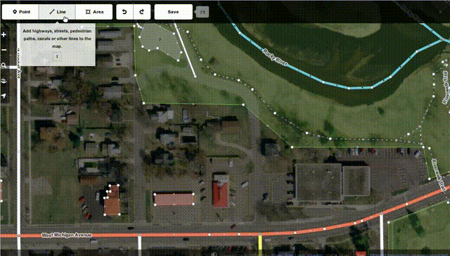
The new iD editor is a pure HTML5 experience, using the cutting-edge D3 visualisation library. Behind the clear design and intuitive interface is a sophisticated back-end that automatically recommends the most popular ‘tagging’ conventions used by the OSM community.

Development began as a community project in July 2012, and has since been taken forward thanks to a $575,000 grant from the Knight Foundation, with development being co-ordinated by MapBox – one of several companies which offer commercial services on OpenStreetMap’s open data.

From later today, new OpenStreetMap users with a modern browser will automatically use the new iD editor. Users can switch between this and the existing Flash-based Potlatch 2 editor (which is being refocused as a tool for intermediate users) using their settings page or the drop-down ‘Edit’ menu. Advanced desktop-based editors are also available.

The editor software is entirely open source, with code available on github under an ultra-permissive licence.

The funding drive

The funding appeal will pay for additional server infrastructure at the heart of OpenStreetMap – where the geographic data and edits are stored – and other key hardware upgrades to improve reliability and performance.

The new server will greatly increase the reliability and performance of OSM’s website and editing service, such that the editing database continues to be available even if one server fails, and providing a more responsive experience when users upload their changes to the map.

OpenStreetMap’s volunteer-led operations team has put a lot of work into designing the new server for maximum performance. Together, these investments will lay the foundation for the continuing growth of OpenStreetMap over the years to come.

You can contribute directly to the appeal at donate.openstreetmap.org, or contact the OpenStreetMap Foundation for more information about sponsoring. Technical details are available on the OpenStreetMap community wiki.

Update 13 May 2013: Bitcoin Donation? Our Address is 1J3pt9koWJZTo2jarg98RL89iJqff9Kobp

OpenStreetMap opens up to more contributors with easy ‘add a note’ feature

OpenStreetMap, the collaborative map of the world often called “the Wikipedia of mapping”, has unveiled a new feature designed to make it even easier to contribute.

For the first time, anyone viewing the map can suggest a correction – such as a renamed business, a missing footpath, or a changed road layout – without learning to use map editor software.

notes screenshot

The corrections will be picked up by OpenStreetMap’s million-strong army of volunteer mappers. A local mapper can visit the location to check the suggested information, and then update the map.

OpenStreetMap’s data is used by some of the biggest mapping names on the web, including Foursquare, Craigslist, Wikipedia, Mapquest, and Apple’s iOS Maps app. It is also extensively used in humanitarian operations, most famously after the Haiti earthquake of 2010.

The new feature is part of a drive to open up OpenStreetMap contributions to more people – so that everyone can add their local knowledge to the map. Later this spring, an all-new HTML5 map editor will be coming to openstreetmap.org; its intuitive controls and clear walk-throughs will encourage more map users to take the plunge and become map editors.

“It’s the detailed local knowledge of our contributors that makes OpenStreetMap so much in demand from web and app developers,” explained Simon Poole, Chairman of the non-profit OpenStreetMap Foundation and a Switzerland-based mapper himself.

“By making it even easier to add to the map, we’re increasing the amount of on-the-ground knowledge we can capture – further distancing OSM from the traditional map data companies and their lack of local expertise.”

To add a note or correction to OpenStreetMap, find your area on openstreetmap.org and click ‘Add a note’ in the bottom right corner.

Background information

Notes are freeform natural text, read by other people, making this is a very simple way to communicate any problems we notice about the map without needing to get to grips with OpenStreetMap and its tagging system. Although this functionality has been available for a while on the third party site OpenStreetBugs, adding it to the main OpenStreetMap site brings it to a much greater audience.

Although it is not necessary to have an OSM account to create a note or comment on it, registered users can see all the notes they have created or commented on, and will receive automatic email notifications if the status of a note changes. OpenStreetMap’s enthusiastic community is its greatest strength, and these notifications facilitate an exchange between the original reporter and experienced mappers.

A full API is available for the notes so that third party sites or apps can query existing notes, create and comment on them – opening up possibilities for mobile bug reporting and fixing. The system is expressly designed for high-quality reports from individual users, not automated error checks or ‘bots’.

OpenStreetMap takes copyright very seriously. Registered users agree not to copy from other maps when signing up, and are requested to verify each suggested correction from non-registered users using ‘on the ground’ information. OpenStreetMap is a map for the people, by the people, and made with personal local knowledge.

Further details are available on the OpenStreetMap community wiki.

Weekly OSM Summary #67

April 8th, 2013 – April 22nd, 2013
A summary of all the things happening in the OpenStreetMap world.

  • Follow Live Edits made to the OpenStreetMap database. And a second webpage with a similar visualization.
  • A new update to the RFC OSM attribution mark.
  • The TOP 50 Mappers of the United States will get a ticket discount of 50% for the upcoming State of the Map US in San Francisco. Read more here.
  • The released GPX Planet dump visualized as a transparent overlay, created by Ilya Zverev.
  • The Overpass Turbo tool now supports MapCSS.
  • A blog article by Young Hahn about „Hack Your Maps
  • A blog article about Kite-Mapping
  • Using fieldpapers in the OSM editor JOSM.
  • Using R to analyze OSM data. A diary entry by Hawkeye.
  • A blog post about the latest HOT activities in Africa. Also, HOT started a new project after the earthquake in Lushan (China). The summaries of the HOT board meetings are online here too.
  • The open source tool Mapwarper helps you to rectify your old and new maps.
  • A new OSM renderer called alaCarte is available at github.
  • A research study about the impact of mapping parties in London.
  • Ten fascinating facts about OSM United Kingdom & OSGB.
  • Celebrate National Park Week with Chimani’s OSM based app for outdoor activities.
  • The next Wherecamp Berlin will be between June 21st and 22nd, 2013.

Authors: Pascal & Dennis – (thx @ “Wochennotiz”)

State of the Map – Call for Papers

The call for papers for State of the Map-Birmingham is now open.

Rob Nickerson, of the State of the Map organizing committee, sends the following information for you.

It’s that time of year again when we look to you, the mind-bogglingly creative OpenStreetMap community, to tell us what you’ve been up to. That’s right – it time to submit your presentation ideas for the annual State of the Map conference.

Presentations

State of the Map 2013, to be held in Birmingham, United Kingdom, from 6 to 8 September is calling for presentations.

The theme of this year’s conference is “Change” so we are particularly interested in presentations addressing this theme. Our programme will cover a wide range of topics that will interest everyone from the new OpenStreetMap contributor to the old hand to the professional contemplating using our data.

If you have something interesting to present about your work with OpenStreetMap and would like to tell the world, we would love to hear about it. Simply fill out the Call for Presentations form explaining the topic of your presentation. To keep things easy, at this stage we just need a few words, not a full presentation. 🙂

Who can present?

We are seeking presentations from businesses, the public sector, charities, and individuals.

Poster Exhibition

This year I personally want to try and get as many people involved as possible. We are therefore hoping to have a Poster Exhibition for people who may not be able to attend in person (we can print them locally). If this sounds interesting to you, please use the same form and specify “Poster” as the “Session Format”. Posters can be mainly pictorial, or include text. You can bring it yourself or send an electronic copy for local printing

Sponsor the poster exhibition

Sponsorship to cover printing costs would be much appreciated.

If you have something to say, for example, about switching to OSM, barriers to its use, apps for mobile mapping, changing community organisation or behaviour, historical mapping, or just anything that you want to present, then make sure you register your proposal with a a few words to describe the topic.

Tutorials

Tutorial sessions are especially welcome!

Deadline

Call for Presentations closes on Monday, 10 June 2013.

About State of the Map

The State of the Map is the official, annual, international, OpenStreetMap conference. Founded in 2007, previous State of the Map conferences were held in Manchester, Limerick, Amsterdam, Girona, Denver and Tokyo.

Weekly OSM Summary #66

March 25th, 2013 – April 8th, 2013

A summary of all the things happening in the OpenStreetMap (OSM) world.

  • The new OSM iD editor reached version Beta 1. You can also find some slides by John Firebaugh that include some background information of iD here.
  • Is someone interested in taking over the OSM editor Merkaartor? Read more here.
  • A first initial dump of all OSM GPX tracks is downloadable now. You can find additional information in the following thread.
  • Frederik Ramm wrote an article about his work at the OSM Foundation Data Working Group.
  • The OSM Inspector Routing View is now available for the whole world as a single layer.
  • A Youtube video about the “ViaAlpin” mapping party.
  • A new mailing list has been created for discussions and questions about tile-serving.
  • The rendering of the OSM France tile server has a neat visualization for soccer and golf fields.
  • Simon Poole’s QA Map service has a new layer. It can highlight way objects with and without name or address-tags.
  • Matthias created a video about the integration of OSM data into SuperTuxKart game.
  • Some notes from the latest HOT meetings and an update on Kunduz mapping.
  • The website formally known as http://www.pistes-nordiques.org , is now available at: http://www.opensnowmap.org . You can find some additional information here.
  • Several US users had some issues using the Overpass-API. This has been fixed now.
  • How to use OSM map tiles from Stamen or MapBox as basemaps in ArcGIS.com.

Did we miss something? You can contact us via weekly.osm@googlemail.com

Authors: Pascal & Dennis – (thx @ “Wochennotiz”)