Author Archives: OpenStreetMap

About OpenStreetMap

Posts written "by OpenStreetMap" were written collaboratively by the Communication Working Group and/or other OpenStreetMap Foundation folks.

Bing Streetside imagery now available in OpenStreetMap iD editor

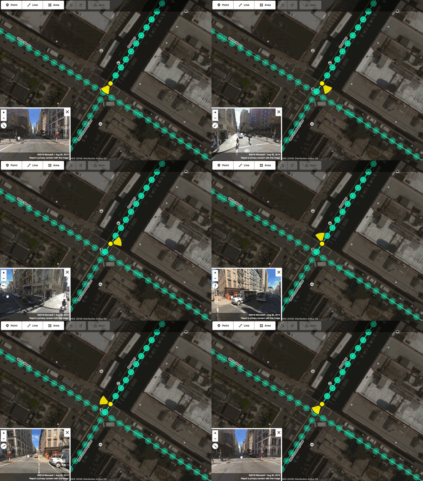
Interactive Bing Streetside viewer embedded in the iD editor © CC-BY-SA

We are excited to announce that you can now use Bing Streetside photographs when you edit OpenStreetMap using the web-based editor iD! This is the same imagery currently visible on Bing Maps. You can activate the Bing Streetside layer in iD by opening the Map Data pane (shortcut F). The new layer provides 360-degree panoramic imagery across large regions of the United States, United Kingdom, France, and Spain. The massive imagery dataset covers approximately 1.6 million kilometers and takes nearly 5PB of storage! Thank you, Microsoft.

Go on – try it!

Other street-level imagery datasets in iD
This street-level imagery dataset in an addition to the existing ones provided in iD by OpenStreetCam and Mapillary, which you can also activate by opening the Map Data pane (shortcut F).

If you find street photography helpful for OpenStreetMap editing, you can also contribute your own photographs, using the Mapillary and OpenStreetCam smartphone applications. These are developed by companies independent from the OpenStreetMap Foundation.

A reminder about photomapping
Are you a new mapper excited about photomapping? Please remember that on-the-ground survey is always superior, as photographs represent a specific time snapshot. Feel free to improve the map using photographs, just keep in mind that the photos might be old. Before changing someone else’s edits, consider contacting the mapper first.

Street-level imagery in other OSM editors
Street-level photographs are also available for improving the map in other popular OpenStreetMap editors, such as JOSM. The Bing Streetside imagery will probably become available in some of these editors soon, so stay tuned!

Happy mapping!

About iD
The iD map editor is an open source project. You can submit bug reports, help out, or learn more by visiting the project page on GitHub.

Check in to State of the Map 2018

State of the Map is all about the coming together of the OpenStreetMap community but this doesn’t have to be limited to the conference venue. Working with our travel partner (they also do our scholarship travel and – free of charge – arranged the venue for the social event), we have rooms set aside at two major hotels just for State of the Map attendees. Rooms cannot be held indefinitely so please book at the earliest possible opportunity to avoid disappointment.

Please use the below link to reserve your room.

For any queries relating to accommodation, please contact Gwen Manac’h on +442079027760 or gwen.manach@gdg.travel.

The State of the Map program is out!

Politecnico di Milano, inner courtyard. Photograph by Alessandro Palmas.

Read the program and immediately realize you can’t miss the next State of the Map 2018 in Milan.

In addition to many interesting talks and workshops, for the first time you can join the Academic Track: a full day session that aims to bring together and foster interactions between OpenStreetMap contributors and researchers.

You will meet OpenStreetMap enthusiasts from all over the world, and discover new local mapping efforts from the last year. The program features members of the community, researchers, new voices, experiences switching to OSM, crisis mapping, new technical tools, company perspectices, projects from every corner of the planet, big data management and much more.

The venue has two main rooms and four additional halls. If you need space for an impromptu gathering, you will always find at least one available room. And don’t be afraid to share your ideas: if you have a last minute idea for a lighting talk you can “book” a 5 minute slot by writing the title on the flipchart at the welcome desk!

Are you still in doubt? We are sure you don’t want to miss the social event on Saturday evening at Old Fashion, close to the beautiful Castello Sforzesco, with live music and drinks.

What are you waiting for? Hurry up and buy a ticket!

Your State of the Map team

Preparing for the GDPR

Modified image. Original by TheDigitalArtist. Licence: CC0

The OSMF board and OSM working groups are preparing for upcoming legal changes regarding data protection rules. The General Data Protection Regulations (GDPR) come into effect in the EU on May 25, 2018. OpenStreetMap Foundation (OSMF), as a legal entity in the EU, is legally required to be compliant with GDPR. The OpenStreetMap License Working Group (LWG) wrote a white paper about GDPR to inform how we should prepare. To that end, we made a GDPR preparedness plan to be implemented over the next months. Many of the required changes are administrative. We want to help you understand what is changing based on how you might use OSM.

Here are some key points to help you learn more:

Do you use OSM to navigate the world?

OpenStreetMap is the free and open map of the world. If you are using OSM to navigate the world, there are no changes. Examples include viewing some form of maps and/or searching points of interest information, and routing instructions.

Do you contribute data to OSM?

Your contributions will not change. However, OSMF will update the Privacy Policy to specifically detail how personal data is collected and processed in accordance with GDPR. Please read that update when it comes out.

In addition, once OSM’s GDPR plan is fully implemented, access to metadata that may contain personal data will be limited. (Access to other data will not be affected. To see which API calls will be affected, please see this page on the wiki). Whether you as a contributor/edit user see changes as a result of these limitations will depend on which editor you use and whether the maintainers of a program you use make any alterations as a result of GDPR. OSMF will strive to help the maintainers of popular editors understand how these changes affect them. Please keep an eye out for further communications.

Are you a Service Provider that uses OSM?

If you are working on a project (e.g. software) that uses the types of OSM metadata most likely to contain personal data (the most prominent being usernames, userids, and changeset ids), you will need to abide by OSMF terms designed to protect personal data in order to have access to that data. These terms will be drafted in accordance with GDPR and will be available for the community to read through. Please keep an eye out for this future post.

You should also be aware that, after May 25, 2018, as someone processing personal data from EU residents, you are subject to the GDPR and will need to adapt accordingly. For example, there are transparency requirements as outlined in Art. 14 (https://gdpr-info.eu/art-14-gdpr/). OSMF and the LWG are working on templates to assist in streamlining compliance, but ultimately, you are responsible for GDPR compliance in any processing you do of personal data.

Does your project use OSM metadata?

Projects using metadata will be most impacted. If you are working on a project (e.g. software) that uses OSM metadata (e.g. quality assurance and data validation) this will be subject to the GDPR and will need to be adapted accordingly. Such projects will need to provide the information as outlined in Art. 14 to all OSM contributors and implement their own privacy policies and mechanisms.

What is GDPR?

There are many resources available to learn more about GDPR. Your data use and your data protection are the two key points to remember. The GDPR (EU) regulations can be read in full here. The OSM License Working Group’s GDPR White paper can be reviewed here. Additionally other organisations have created this clear diagram explanation and a checklist.

Is this compatible with ODbL?

Yes. ODbL concerns copyright and database rights. It explicitly disclaims trademark and patent on the IP side (which is why we have a separate trademark policy) or other national laws. It also specifically says “The right to release the Database under different terms, or to stop distributing or making available the Database, is reserved.” Similarly, the Contributor Terms specifically concern IP rights and the license used for them, but do not mention anything else like privacy law.

Find the Implementation plan

The following page will be used to track changes and provide updates. The OSMF board will also coordinate with the Licensing Working Group for further details in the coming weeks:

https://wiki.openstreetmap.org/wiki/GDPR

Questions

The OSMF Board and the various OSM working groups are available to answer key questions.
Come join us at the State of the Map social event!

Night view of the tower of Filarete, which is the central tower of Castello Sforzesco and close to Palazzo dell’Arte. Photograph by Alessandro Prada. Licence: Attribution-ShareAlike 2.0 Generic (CC BY-SA 2.0)

As if a State of the Map schedule full of awesome talks was not social enough, we are packing your Saturday night with an officially sponsored State of the Map social event.

In the heart of the historic Parco Sempione, we will convene at Old Fashion Milano just a few minutes walk from the centre of Milan. With garden terrace, live saxophone, and private DJ set, it’s set to be an exciting night. Feeling the vibe? After 23:00 the club opens to public, and the night continues until 05:00.

Come join us after the social presentations close on Saturday, July 28th for the official State of the Map 2018 social event! The details for your fast recall:

  • Where: Old Fashion Milano
  • Where 2.0: Palazzo dell’Arte, Viale Emilio Alemagna, 6, 20121 Milano
  • When: From 19:30
  • What: Free wine, buffet supper, beer and water
  • Who: Free of charge for anyone registered for State of the Map
  • Why: Because it wouldn’t be State of the Map without it

Participate in our poster competition!

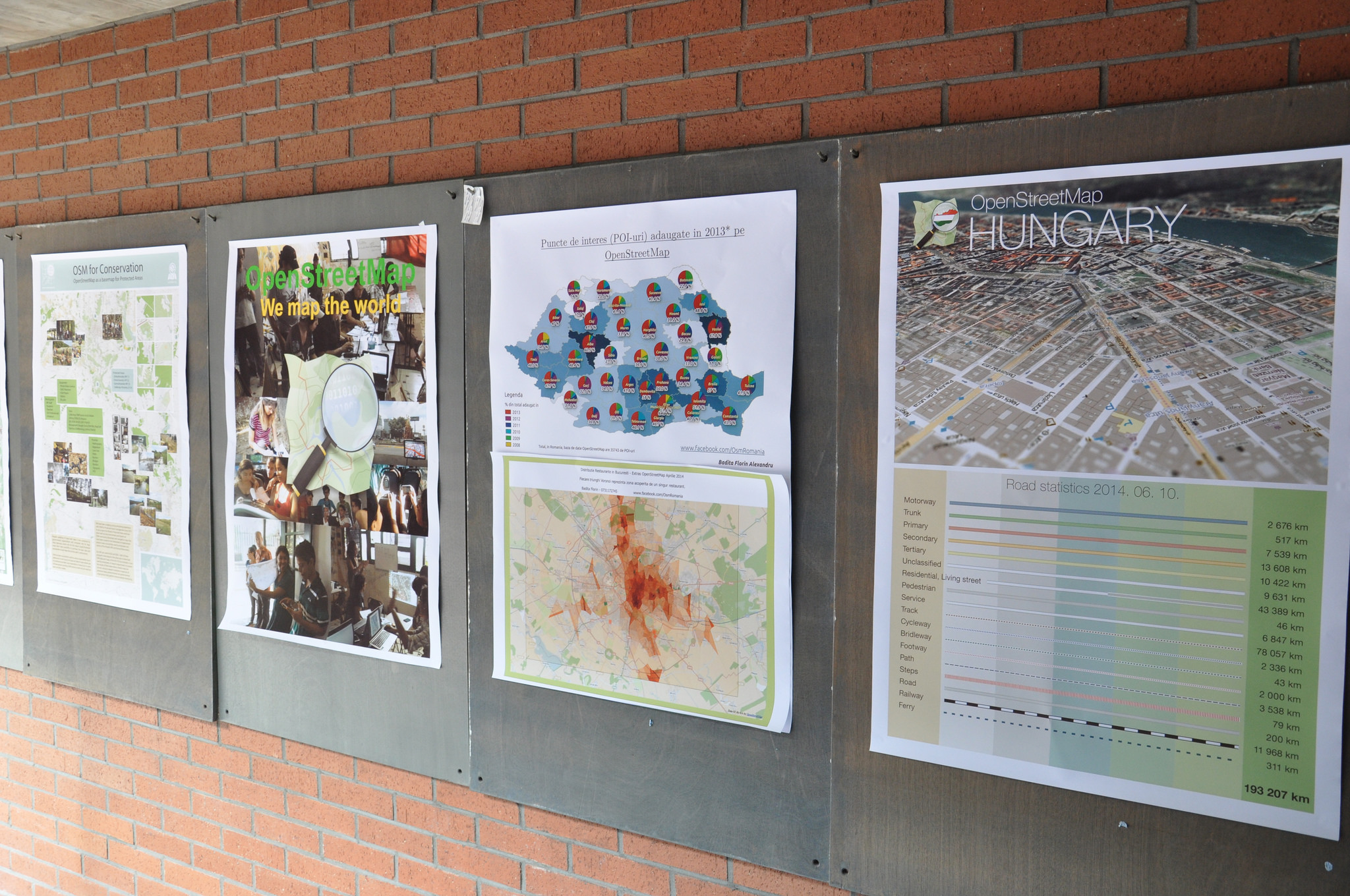
Poster competition at SotM-EU 2014. Photo by Michael Reichert. Licence: Attribution 2.0 Generic (CC BY 2.0)

At State of the Map we love hearing what has been done with open map data, but we also love seeing it too. This year we’re taking inspiration from regional SotM EU conference and holding a poster competition. Your poster could show how well your home is mapped, it could be a beautiful new style or map. It might not focus on a map but instead focus on a community or statistics, it might be a poster explaining and inviting people to OpenStreetMap. What’s important, is we want it to be about OpenStreetMap.

Rules for the competition

  • Poster should be for A0 size (841×1189mm)
  • Poster should be about OpenStreetMap
  • One entry per person

How to enter

  • Upload your poster online
  • Send an e-mail to team@stateofthemap.org with the subject “Poster Entry
  • Include: a link to the image, title of the poster, your name(s), whether you would like to bring the A0 poster or for us to print it. The licence of the submitted works is considered to be CC BY-SA 4.0, unless noted otherwise on the image.

Deadline: 30th June 2018

With the entries

  • The SotM team hope to shortlist up to 20 posters that will be displayed during the State of the Map 2018 conference in Milan
  • During the conference, attendees will be invited to vote on their favourite posters
  • As of this time there are no prizes planned other than the satisfaction of sharing your poster with the State of the Map community.

You don’t have to attend SotM 2018 to enter this competition, but great conversations happen while viewing the posters so grab your SotM tickets here!

Recommendations for new (Pokémon GO) mappers by community members

The post below is a modified version of a message written by Spanholz, with input from other OSM community members, aimed at new mappers coming from Pokémon GO. Modified with permission.

Pokémon GO and Ingress changed their base maps to OpenStreetMap in 2017. A lot of you may have discovered a loss in information on the game map. No building shapes, no parks or footways. But you can add them and help to create a free world map.

What is OpenStreetMap?
OpenStreetMap (OSM) is a map that anyone can edit. There are some similarities to Wikipedia, but there are differences too (if you are a Wikipedia contributor please read this). Everything you see in the world could be on one map. Open data, usable by everyone. Niantic uses OSM data for Pokémon GO, Wheelmap users enrich OpenStreetMap to help people with disabilities and Kurviger can show routes for motorcyclists that are more curvy and outside of residential areas. There are many more examples how the data you contribute is used.

How is it different from other online maps?
OpenStreetMap data is open. You are allowed to commercially print maps based on OSM data, with the appropriate attribution on them. You can take the map data and create your own routing engine. You can create your own map style and use it to visualise OSM data. We believe that geographical information should be available in one big database free for everyone.

Isn’t mapping complicated?
No. The world of OpenStreetMap consists of elements such as points (nodes), lines (ways), areas and relations. They get their values through so called tags (like name=Africa). For example a playground could be outlined as an area and tagged as:
name=Happy faces
leisure=playground
opening_hours=10:00-20:00
We can use nodes for small features like wastebaskets or bicycle repair stations. Ways for roads, paths, small waterways. Areas for forests, buildings and ponds.
See popular features that are mapped (for more, search the wiki).

How can I edit?
We have two main editors for mapping with computers, iD, a browser editor, and JOSM, an advanced standalone editor. To add things with your smartphone you can use mobile apps which also display the map you help to enrich. See some of the editors.

What are the most important rules?

  • Don’t use copyrighted sources (maps, databases, photographs).
  • Map what’s on the ground.
  • Have fun creating the best map ever!

Where to find help

  • Search the Wiki, many tags are described there. Read the discussion pages of the tags or search the archive of the tagging mailing list.
  • Look at other parts of the world, where something is already mapped. Look in bigger cities or in Europe, where things are mapped to the greatest detail (yes, there are people who add the colour of waste bins!)
  • Ask! Other mappers will help you, ask on help.openstreetmap.org, on the forum, on country-specific OSM mailing lists and IRC channels or on /r/openstreetmap. You can also find community channels on most social media.

You should know

  • Your changes do not go through an approval process. Please be considerate and only add correct information, as the data is used by drivers, pedestrians, cyclists and even canoeists!
  • You are free to create tags, if you don’t find an appropriate one on the wiki or elsewhere.
  • The wiki is helpful but some pages might have inconsistencies or have suggestions that deviate from common practices.
  • You don’t have to create an official proposal of a new tag on the wiki – but creating one will probably provide you with useful feedback and increase its visibility.
  • Aerial imagery might be old. It could also be offset – compare with gps traces.

What is good mapping?

We have got you covered: Good practices primer!
For example,

    • Don’t use the name tag to describe the object. name=bench is wrong, amenity=bench is right. The name tag should only be used for features with actual names, like schools or restaurants (see Names).
    • Don’t connect landuses with streets. It’s hard to change something afterwards and also confusing.
    • Don’t uncritically delete stuff. First ask the mapper why s/he did something the way s/he did. Maybe you just have old satellite data.
    • OSM data can be visualised in many different ways on various websites or apps – please do not add incorrect tags just to see something rendered on www.openstreetmap.org.

What else?

This website by Pascal Neis shows you other mappers near you, if you want to connect.
Upcoming OSM Events. Maybe there’s a social meet up near you. It’s always good to talk to people face to face.

Have fun creating the best map ever!

Pokémon GO is a hugely popular mobile game which uses OpenStreetMap data to influence “spawn points” within the game. It always takes new folks some time to get to know OpenStreetMap, and we hope Pokémon Go players will stick around to contribute some more.

OpenStreetMap is a world-wide collaborative project aiming at providing free map data, under an open license, to anyone who wants it. Volunteers all over the planet contribute their local knowledge and their time to build the best map ever. You can contribute by improving the map, uploading GPS traces, increasing awareness about the project, editing or translating the wiki, becoming a member of the volunteer Working Groups, donating or joining the OSM Foundation. You don’t have to be a member of the Foundation in order to edit OpenStreetMap.

How the new Niantic – OpenStreetMap Foundation collaboration affects mappers coming from Pokémon GO

Happy April 1st everyone! We would be really happy if this announcement was real (but it’s not 🙂 ). We still want to encourage everyone to add correct information to the map, read the links with the tips (1, 2) and get more involved. Many thanks to all Pokémon GO trainers who have correctly mapped their areas. Happy mapping!

OSM logo by Ken Vermette, Pikachu image CC BY-NC.

During the last year the OpenStreetMap community has seen an influx of mappers coming from Pokémon GO, as the hugely popular mobile game was found to be using OSM data to influence “spawn points” within the game. New mappers were welcomed and we shared some tips with them. We got a few people addicted to mapping, new places were mapped and help received a lot of questions. The flurry of new map editing activity also had some unfortunate side-effects, as a few new mappers tried to game the system by adding things that did not exist or by assigning the wrong tags.

Use of leisure=park from 2013 to 2018. Source: http://taghistory.raifer.tech/


The OpenStreetMap Foundation has been in contact with Niantic and we are in the happy position to announce a collaboration! Niantic, wanting to show their support to the project, will become our first Rubidium Corporate Member and is also in the process of adjusting their algorithms so that areas with good map edits get more spawn points, while areas where players try to game the system get penalised. While the implementation will be gradual, it will take into account all edits that have happened in an area for the last 1.5 years and it will use a scoring system to determine the increase (or decrease) of spawn points. That means that the good mapping habits of you and your nearby players can positively affect your game.

“Niantic is in the process of adjusting their algorithms so that areas with good map edits get more spawn points, while areas where players try to game the system get penalised.”

What you can do:
Read our tips.
Read recommendations collected from community members.

In addition to that, there are plans to reward other contributions to OpenStreetMap as well. To begin with, for every accepted pull request to core software of the OpenStreetMap infrastructure, the trainer will be rewarded with an unique opportunity to obtain some legendary Pokémon – including those which were up to now only available during limited-time events! At a later stage, we’re planning to use a more elaborate algorithm, which may also include the trainer’s wiki profile, help karma points and other contributor metrics, so stay tuned! The OSMF has approached the creator of the popular “How did you contribute” service, Pascal Neis, to work with Niantic to find  the most effective way to determine a trainer’s score.

We encourage all players of Pokémon GO to take advantage of this early release statement and go out to map, write code or help to enhance the wiki pages!

Pokémon GO is a hugely popular mobile game which uses OpenStreetMap data to influence “spawn points” within the game. It always takes new folks some time to get to know OpenStreetMap, and we hope Pokémon GO players will stick around to contribute some more.
OpenStreetMap is a world-wide collaborative project aiming at providing free map data, under an open license, to anyone who wants it. Volunteers all over the planet contribute their local knowledge and their time to build the best map ever. You can contribute by improving the map, uploading GPS traces, increasing awareness about the project, editing or translating the wiki, becoming a member of the volunteer Working Groups, donating or joining the OSM Foundation. You don’t have to be a member of the Foundation in order to edit OpenStreetMap.

State of the Map 2019 – Call for Venues Open


The call for venues for State of the Map 2019 is now open:

State of the Map 2019 – Call for venues

Assemble your team and propose your city as host for the next OpenStreetmap conference. The State of the Map working group helps you. We encourage you to contact us on team@stateofthemap.org as early as possible so that we can provide guidance if required.

Submit your proposal by 6th May 2018.

Community survey for the State of the Map 2018 program

Community voting for State of the Map 2018 is now open! Inspired by the community that makes OpenStreetMap a reality we want your help in shaping this year’s program.

The People Speak! by saulalbert. Licence: Attribution 2.0 Generic (CC BY 2.0)

Thank you everyone for submitting session proposals for State of the Map 2018. We have a great line up of presentations this year, it is time to share your views and help shape the State of the Map 2018 program.

Please participate in our OpenStreetMap community survey. It’s open to all, whether you are planning a trip to Milan, attending virtually on the live streams, or just enjoying our session videos afterwards.

Once past the front page you will be presented with a long list of talks to rate, sorted at random. We don’t expect you to rate all 134 talks; if each person reading this just did 10 then we would end up with a large amount of valuable data. When you’ve got as far as you’d like, just scroll down, hit Next until you can Submit your answers. Just don’t leave the page open for too long, as your session might time out. Note: Use of OSM usernames helps us with spam detection – we won’t share them with anyone.

You matter in the creation of OpenStreetMap and we want your voice to be heard in the creation of its conference. The survey is only open until 20th March 2018, so go to the survey now!

The State of the Map (SotM) conference is the annual, international conference of OpenStreetMap. Organised by the OpenStreetMap Foundation it has been held each year since 2007 (except 2015). State of the Map 2018 will take place in Milan (July 28 – 30, 2018).